This MODERATE hike closely parallels the Mad River, with two steep stairways up to a height of land [1500 ft.], offering interesting river views.
The trail begins off the Mad River cross-country ski trail [also part of the “Fit Trail”]. From Town Square, cross the dam and turn right on the Village X-C Ski Trail, and then right on a bridge over Snows Brook. Tylers Spring Trail diverges right before another bridge, this one over the Mad River. At the bottom of where the ski trail rises up the hillside, the Mad River hiking trail heads into the woods. After a small bridge over a thin rill, and a series of steep rock steps up to a plateau, the trail walks along the high and steep-sided glacial riverbank. It soon descends steeply on another long series of wooden steps, down to the river’s shore, crosses another rill without a bridge [may be difficult in high water]; and then, crosses over a small footbridge, and a larger footbridge at the confluence with the West Branch of the Mad River. The final section easily traces the river and ends at West Branch Road.
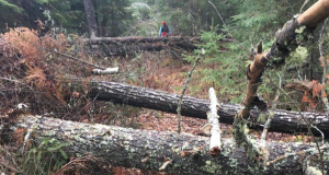
This trail was severely damaged by tropical storm Irene in September, 2011. It was restored during 2012 as a result of funding provided by the Town of Waterville Valley and a trail work project managed by the WVAIA. You can read an account of the restoration effort here.
The high waters of spring 2014 caused the new stepping stones across the West Branch of the Mad River to shift. They have since been reset and the crossing is once again ready to use.