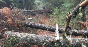
This MODERATE route [a dirt road at first] connects Waterville Valley to the Kancamagus Highway, reaching a height of land known as Livermore Pass [3000ft.], and serves as access to most of the valley’s hiking trails.
It begins as a Forest Service gated road off the Livermore parking lot. After the clearing known as Depot Camp, Greeley Ponds Trail is on your left, 10 minutes from the parking lot. Boulder Path [15 min.] diverges right and crosses the river just before a short rise in the road. Big Pines Path [20 min.], is on the left, followed by Irene’s Path [25 min.], also on the left. The road continues with more ascending, before Norway Rapids Trail [45 min.], diverges right. Livermore Road ends and Livermore Trail [55 min.] begins at a bridge over the Slide Brook. From there, it climbs more steeply to the Mount Tripyramid Trail [65 min.], leading to the South Slide. The Mount Tripyramid Trail [1:30 min] that brings you to the North Slide, diverges right at a hairpin turn. It is then just a few minutes up the road to the Scaur Ridge Trail, and then the Old Skidder Trail [1:50 min.]. From this point on, the Livermore Trail is used primarily as a x-c ski route as it continues past the Kancamagus X-C Ski Trail on the left, through the Livermore Pass, which is wet and muddy, sparsley blazed and difficult to follow. The descent to the Kancamagus Highway is gradual and seldom used by hikers.