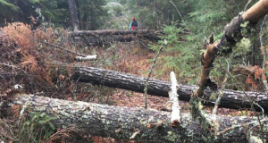
This trail was newly created and opened for hiking in late 2014. It provides access to the the Flume [2500 ft.], a picturesque cascade and pool flanked by high rock walls. Much smaller than The Flume in Franconia, it’s remote, infrequently visited; and therefore, ideal for those seeking beauty and solitude. Along the way, it passes the Kettles, three kettle-shaped indentaions in the earth. They were formed when receding chunks of glacial ice broke off and were subsequently run-over by the receding glacier, which covered it with layers of sediment. When the ice of the broken-off chunk melted beneath the sediment, the earth dropped down, creating a “kettle.”
Irene’s Path includes the former Kettles Path, which has been retired and the portion of the Scaur Trail that ran from its junction with the Kettles Path up to the Scaur Overlook.
Irene’s Path begins off Livermore Road not long after the Big Pines Path and meanders through a flat hardwood forest. Soon it ascends the steep foothills of the Scaur Ridge, via short stone and wooden steps up to a flat terrace. Here, it runs along side the kettles, best observed in the leafless seasons. After crossing a spring-fed rill, it turns right and goes uphill on the route of the former Scaur Trail. In about 15 minutes, a short spurt trail leads to the Scaur Overlook. Irene’s Path continues onward to reach The Flume.